George Washington's Maps of the Upper Potomac
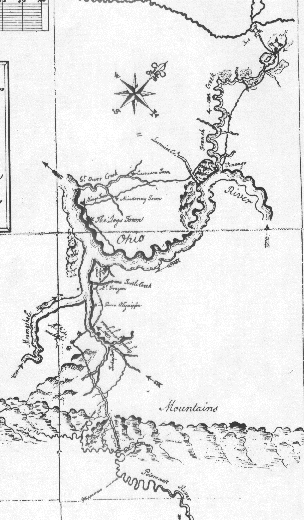


Portion of George Washington's Map of the Ohio Country,
drawn after his mission to the French Commander
in the Winter of 1753-54. (Library of Congress,
Geography & Maps Division)


George Washington's sketch of the rapids
below Harpers Ferry. (July or August, 1754)
(Library of Congress, Geography & Maps Division)

Washington's notes accompanying his 1754 map:

Reference Above the Mouh of Shanh there is but one fall and that is smooth and shallow which prevents Craft from passing at all times--Abt 1/2 mile below is the place Esteem'd the most difficult It runs Exceedingly swift for wch reason it is call'd the spout and the bottom being very Rocky occasions rough water which will prevent small Canoes ever passing as our's that was large had like to have fill'd--There continues for near three Miles Rocky & uneven--Water in which diste and towards the latter end there is two other Falls one swift & ugly but when the River is higher than ordinary a passage may be had rd a small Island--which passage may be greatly improved--There also a passage at the spout which vessels may, and have been hald up by near

the shoar, and this may yet be improved--Abt 12 Miles below this is another Fall but very easy and passable and abt 2 Miles from that is a cluster of small Islands with many Rocks and swift water which render's the passage somewhat precarious: from this to the Seneca Fall' is a fine smooth even Water as can be desir'd The Seneca Fall is easily pass'd in two places and Canoes may continue within two Miles of the Great Falls but further it is not pos therefore the expence and trouble of going up Seneca Falls will not answer the Charges as all Carriages are oblig'd to pass difficult Bridge from whence it is but 8 miles to the Landing place at Mr Barnes Quarter at the Sugarlands and is 5 miles to any Landing below the aforesd Falls of Seneca.


George Washington's sketch of the site of
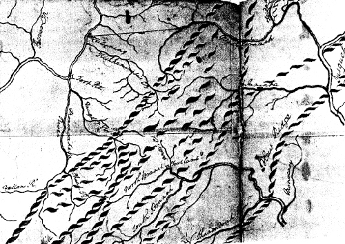
Fort Cumberland at Will's Creek (1755?).
(Library of Congress, Geography & Maps Division)


Detail of the "Walker-Washington" map.
(Library of Congress, Geography & Maps Division)

George Washington probably made this copy in Decembe, 1769 from a map presented to the Virginia House of Burgesses by Dr. Thomas Walker. The main purpose of Walker's map was to establish the boundary line between the Virginia settlements and the western lands belonging to the Cherokees, relative to the Treaty of Hard Labor (concluded with the Cherokees in Hard Labor, North Carolina on October 14, 1768). This line ran through the southwestern portion of Virginia. The map also shows the Appalachian range in vicinity of the Potomac, territory that was of great interest to Washington, who would be making a trip across those mountains in October 1770 to determine the extent of the lands that had been promised by Virginia's Governor Dinwiddie to veterans of Washington's 1754 campaign to the Forks of the Ohio that touched off the French and Indian Wars.

This map is in Washington's hand, but has a notation: "Aligany/Copied from a Map of/Doct.r Walkers/laid before the Assembly." Walker's map has not been found, so we cannot tell for certain what elements were added by Washington. However, one scholar suggests that the distinctive spelling of certain place-names indicates that Washington may have added some features from Lewis Evans' 1755 map of the region.

Copies of maps from Library of Congress Geography and Maps Division (map of the Ohio Country and Fort Cumberland sketch) and National Archives (falls below Harpers Ferry); also included in the Atlas of George Washington.

Sources:

  • See the notes to Washington's sketch of the falls below Harper's Ferry in The Papers of George Washington, Colonial Series, Volume 1, 1748-August 1755, W.W. Abbott, Editor, University Press of Virginia, Charlottesville, 1983
  • GEORGE WASHINGTON ATLAS, edited by Lawrence Martin, George Washington Bicentennial Commissission, Washington, DC, 1932. [Includes several other maps of interest to the region, especially a 1784 map of the trans-Appalachian region attributed to Washington, but now believed to be by Norman Bruce, as annotated by Washington.]
  • Virginia in Maps: Four Centuries of Settlement, Growth, and Development, edited by Richard Stephenson and Marianne M. McKee, The Library of Virginia, Richmond, VA, 2000. Michel's map, held in the Public Records Office in London, is reproduced on page 44.
  • "The Walker-Washington Map," by Paul G. Sifton, in the Quarterly Journal of the Library of Congress, April 1967, reprinted in A La Carte,Selected Papers on Maps and Atlases, Compiled by Walter W. Ristow, Geography and Map Division, Library of Congress, Washington, DC, 1972.


| Home | C&O Canal | Historical Sketch | Falls Region | Piedmont and the Sugar Lands | Blue Ridge & Great Valley | The Endless Mountains |   mike.high@lesserscribe.net